


A trip to Michigan should be taken in parts to allow a full appreciation for The Mitten. Northwest lower Michigan is often referred to as the flatlands, and its residents “flatlanders,” by those in the UP. The nickname is a somewhat kinder reference when compared to “trolls,” the name given to those in the lower peninsula as such because they are south of the Mackinac Bridge, and therefore must live under it, like a troll.
The lower peninsula of Michigan is bounded on the west by Lake Michigan and to the northeast by Lake Huron. The land is typically level but has conical hills and glacial moraines not more than a few hundred feet tall, which are common in the north. The west coast enjoys extensive beaches and dunes along Lake Michigan and the winds from the west. No matter where you live on The Mitten, you are never more than 6 miles from a body of water and 85 miles from a Great Lake.
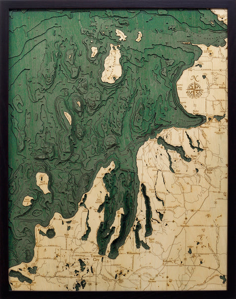
The Northwest Lower Michigan nautical wood chart is made of high-quality Birch. The wood map displays the topography of the area in intricate detail. The depths of the lakes and bays and details of the coast are expertly etched in the high-quality birch and completed with engraved points of interest. The wood map is finished in a solid wood frame and arrives ready to hang.
Bring home the adventures of Up North with your own Northwest Lower Michigan 3D nautical lake art.
Points of Interest on the Northwest Lower Michigan Lake Art:
Beaver Island, Charlevoix, Grand Traverse Bay, Lake Michigan, Leelanau Peninsula, North Manitou Island, Petoskey, South Manitou Island, Straits of Mackinac, and Sturgeon Bay
Our wood charts are made from High-quality birch and have a solid wood frame. They come ready to hang and we will provide free shipping within the continental United States.
NOW AVAILABLE IN 3 FRAME STYLES! Choose between our classic, dark brown frame and our new Grey frame.